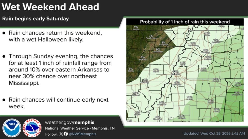
The DeSoto County Halloween forecast calls for rain on Saturday, Oct. 31, with showers and thunderstorms likely after dark, according to the National Weather Service in Memphis. Families planning to trick-or-treat in Southaven, Olive Branch, Horn Lake, Hernando, Walls and the rest of the county may want to head out early and pack rain gear.
The rain will be welcome after weeks of drought, burn bans and fire danger warnings across North Mississippi. Forecasters say it probably won’t be enough to end the dry spell.
DeSoto County Halloween Forecast: What to Expect Saturday
As of Wednesday morning, the NWS point forecast for the Southaven area shows:
Thursday and Friday: Mostly sunny to partly sunny, with highs near 81–82 degrees.
Friday night: Clouds move in, with a slight (20%) chance of showers after 1 a.m.
Saturday (Halloween): Mostly cloudy, with a 40% chance of showers during the day. Highs reach the mid-to-upper 70s, then temperatures drop to around 74 in the afternoon.
Halloween night: Rain chances climb to 70%, with showers and thunderstorms likely after 7 p.m. Low around 59.
Sunday: A 50% chance of showers and thunderstorms, with a high near 74.
In its Wednesday forecast discussion, the Memphis office said the latest guidance has the bulk of the rain arriving later, mostly after 7 p.m. Halloween night. Forecasters added that one major model, the GFS, remains an outlier with an earlier start time, so the timing could still shift.
How Much Rain Will Fall?
Don’t expect a drought-busting soaker. The weather service puts the chance of at least 1 inch of rain through Sunday evening at about 15% for Hernando and 13% for Memphis. Odds run higher to the east, near 30% in northeast Mississippi. Forecasters said the heaviest totals are most likely along the Tennessee River Valley, with lesser amounts elsewhere.
That matters because much of the Mid-South, including northwest Mississippi, is in extreme drought on the latest U.S. Drought Monitor map. The NWS said dry conditions and lingering drought keep fire risk elevated through Thursday, and residents should keep following all local burn bans until wetting rain arrives.
Halloween Safety Tips for a Wet Night
If storms develop Saturday evening, a few simple steps can keep trick-or-treaters safe:
Plan to go out earlier in the evening, before the heaviest rain is expected.
Add reflective tape or carry flashlights. Wet roads and dark skies make costumed kids harder for drivers to see.
If you hear thunder, head indoors. Lightning can strike miles from a storm.
Drivers should slow down in neighborhoods and on wet roads like Goodman Road, Highway 51 and Highway 302.
Check the forecast again Saturday afternoon, since timing may change.
More Rain Possible Next Week
After a short break to start the week, another system could bring more rain to the Mid-South early next week. Forecasters said models still disagree on its timing and strength, and the ingredients for severe weather look limited for now. The weather service will keep watching it.
For the latest updates, visit weather.gov/memphis or follow the National Weather Service in Memphis on social media.