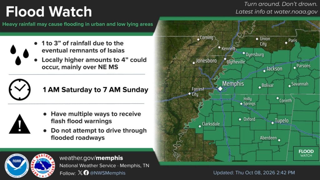
The National Weather Service in Memphis has placed DeSoto County under a Flood Watch as the remnants of Hurricane Isaias move north into the Mid-South this weekend. The DeSoto County flood watch runs from 1 a.m. Saturday, Oct. 10, through 7 a.m. Sunday, Oct. 11, and covers Southaven, Olive Branch, Horn Lake, Hernando, Walls and the rest of the county.
The watch, issued Thursday afternoon, also includes most of North Mississippi and much of West Tennessee, including Shelby County. A watch means flooding is possible. It is not a warning that flooding is happening.
What the DeSoto County Flood Watch Means
Forecasters expect 1 to 3 inches of rain from Isaias’ remnants, with locally higher totals up to 4 inches possible. The heaviest amounts are most likely over northeast Mississippi and near the Tennessee River, but the weather service said heavy downpours could cause runoff into creeks, streams, ditches, and low-lying, flood-prone areas across the watch area.
When: 1 a.m. Saturday to 7 a.m. Sunday
Rain: 1 to 3 inches, locally up to 4 inches
Wind: Sustained winds up to 25 mph, gusts up to 40 mph Saturday
Severe storms: Not currently expected, though brief spin-up tornadoes are possible if the remnants track farther west
Drought Could Make Runoff Worse at First
The rain arrives after a long dry stretch. In its Thursday afternoon forecast discussion, the weather service noted that much of the Mid-South is in severe to extreme drought, with very dry soils after little to no rain in weeks. Hard, dry ground can shed water quickly during heavy bursts of rain instead of soaking it in, which raises the risk of street and ditch flooding even where the rain is badly needed.
Forecasters also said there is still some uncertainty. Their discussion put the chance of more than 3 inches of rain over northern Mississippi at about 30 to 50 percent, while at least one model keeps the Mid-South mostly dry on the west side of the system. The bottom line from the weather service: Saturday is expected to be wet and windy.
A Wind Advisory may be added for parts of the region Saturday in later forecast updates. Rain should move out by around noon Sunday, with drier weather and highs in the 70s to low 80s. Warm, dry conditions with highs back in the 80s to near 90 are expected for most of next week.
How to Prepare Before Saturday
Clear leaves and debris from storm drains, gutters and ditches around your home on Friday.
Secure outdoor furniture, decorations and trash cans that could blow around in 40 mph gusts.
Have more than one way to get weather warnings, such as a weather radio and phone alerts.
Never drive through flooded roads. Turn around, don’t drown.
Check plans for outdoor events Saturday, including fall festivals and the final weekend of the Mid-South Fair in Southaven.
Until the rain arrives, the hot, dry pattern continues. Highs Friday are expected in the mid-80s to low 90s, and a Code Orange ozone advisory was renewed Thursday evening for DeSoto, Shelby and Crittenden counties until sunset, so people with asthma or other breathing problems should limit long outdoor activity.