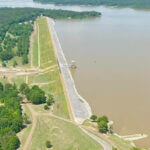
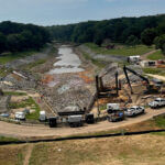
Corps of Engineers assessing Arkabutla conditions, solutions
Photo: Cory Winders with the U.S. Army Corps of Engineers Vicksburg District, gives an update on the Arkabutla Dam situation during Monday’s Board of Supervisors meeting. (Bob Bakken/desotocountynews.com)
Officials with the U.S. Army Corps of Engineers are adamant there is no imminent danger to the public around Arkabutla Dam after a depression was found near the toe of the dam, or where the dam meets the earth.
The discovery ignited concerns that the depression could cause severe foundation loss and a breach if left untreated. The Emergency Operations Center was placed in operation as a result.
While stressing there is no imminent danger, Cory Winders, Hydraulics Branch Chief for the District, told the DeSoto County Board of Supervisors Monday the district won’t know for sure until they lower the lake low enough to get a good look at the problem. Winders told Supervisors he expects repairs to take 2-3 years. This is an issue Winders said won’t be fixed before the end of the week.
“When we started getting phone calls last week, we had people thinking this was going to be done in a couple of days,” Winders said. “It’s going to take until mid-to-late June for us to get the lake level down to 210 (feet). At that point, we’re going to have to reassess to see if it is safe to get out on the dam and do our analysis or if we need to drain the lake some more.”
Winders went on to say the next step would then be determining what repairs need to be done to the 80-year old dam, constructed in 1943. Once it reaches 210 feet elevation, figuring out what repairs are needed could mean the 210 feet elevation must remain there for a lengthy period of time, and then repairs would have to be made.
“That we don’t know,” Winders said. “We don’t know if that would be a year, two years, we don’t know exactly what that time is. This is not a two, three, four day fix. This is a long-term deal.”
Winders added the Corps is trying to determine if boating and recreating opportunities will be affected by the change in lake elevation.
“We are now looking at the recreation areas to see if you can still swim or if people can still access the ramps at an elevation of 210 (feet),” Winders said. “That we will have soon. That’s something we’re checking into right now.”
Farmland downstream from the dam may be affected with the release of water into the Coldwater River down to the 210 feet elevation. No homes will be affected but some farmers planted crops on low-lying land this spring hoping production will help make up for a couple of bad production years prior to this year. That may not happen now.
Winders said it is forecasted the water level at the Marks gage will peak at 34 feet and at 12 feet at the gage in Sarah.
“If there is farmland that was planted at 34 or 35 (feet), that will get impacted,” Winders said. “Some of the low lying areas were planted this year, that’s what we have been told. That’s what we are trying to get into the field and verify right now.”
He added where homes become affected is when the Marks gauge is 39 feet and the Sarah gauge reaches 18 feet.
“We’re going to be way below that,” Winders pointed out. “We’re not going to see any impacts to homes. ”
It’s now believed the 210 foot elevation level will likely occur around June 20 and reaching that date will also significantly reduce the failure risk. The date may change if above normal rainfall happens between now and that date.
Vicksburg District officials say they are committed to working with the Mississippi Emergency Management Agency (MEMA), local law enforcement agencies, and surrounding counties and cities as the situation develops.
Winders told Supervisors this is the first time this much water has been released over a period of weeks.
“We’ve never released that much for that long, so Coldwater River’s going to be really full. My concern from my standpoint is when we get local rainfall, how much is that going to back up these tributaries that drain into the Coldwater? So that is something we’ve got to monitor.”
Arkabutla Dam is 65 feet high, 10,000 feet long and reduces flood risk for 19,000 residents. The dam protects $510 million in homes and businesses.
Additional information about Arkabutla Dam (identification number MS01496) can be found at the National Inventory of Dams (NID) at https://nid.sec.usace.army.mil/#/dams/system/MS01496/summary.
Bottom line: the preliminary work is beginning with the lake level being lowered, but it is too soon to know the severity of the sinkhole problem at the dam’s base, what and how long it will take to solve the issue. Meanwhile, buckle in for a lengthy period of time for the Army Corps of Engineers to fix the problem and people around the dam can be assured knowing there is no imminent danger.


